Farmers across the Midwest, where soils are already saturated, could face more widespread flooding this spring as rivers swell and winter storms continue, forecasters say.
USDA Meteorologist Brad Rippey told Agri-Pulse Tuesday that weather conditions across the upper Midwest and northern Plains are setting up a scenario similar to last year, when wet weather caused problems for farmers looking to plant spring crops.
“As you move into the Midwest and parts of the northern Plains, soils are so saturated,” Rippey said. “As you move into areas like the eastern Dakotas, there is so much snow built up on the ground, it is going to be very tough to avoid flooding.”
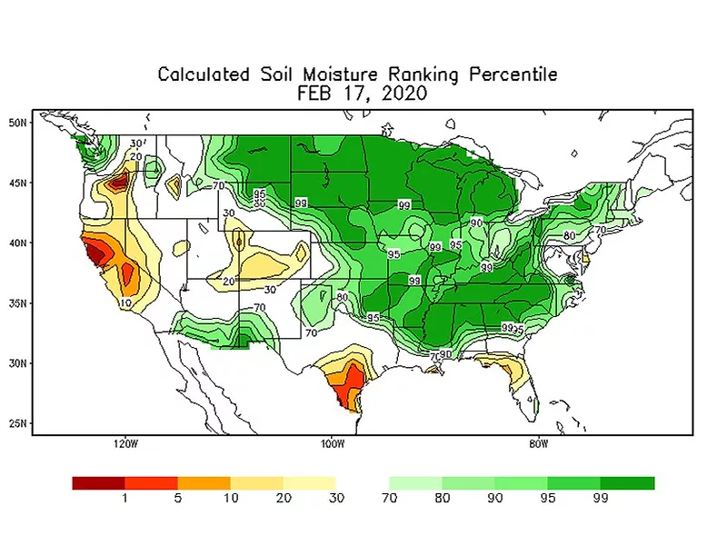
As of Monday, the National Weather Service’s soil moisture rankings show 99% wet conditions across the northern Plains, northern Corn Belt, and interior Southeast. The soil moisture rankings are significantly higher over a wider area than in February 2019.
“Everything seems to be pointing toward wetness both in the past, present, and the future. It does seem to increase the likelihood that there will be spring planting delays widespread in the Midwest again in 2020 like we saw in 2019.”
Scott VanderWal, who farms west of Brookings in eastern South Dakota, said his region has had a lot of snow after starting the winter “really saturated.”
Some farmers have bought seed and inputs for only a portion of their land on the assumption they won’t get all of their acreage planted, said VanderWal, who is vice president of the American Farm Bureau Federation.
“The good news is there is not much frost, and we believe that water has continued to move down through the soil profile and the creeks and streams are still running under comparatively thin ice,” he said.

Scott VanderWal, AFBF
Interested in more coverage and insights? Receive a free month of Agri-Pulse or Agri-Pulse West by clicking here.
Farmers filed 2019 prevent planting insurance claims on 19.1 million acres, claiming indemnities totaling $4.3 billion, according to data that the administrator of USDA’s Risk Management Agency, Martin Barbre, presented at the annual Crop Insurance Industry Convention on Tuesday.
VanderWal’s state had the largest number of prevent plant acres, 3.91 million, followed by Illinois and Ohio at 1.44 million acres each. Missouri was next at 1.32 million acres.
The spring flood risk is “above normal to well above normal” across the eastern portion of the Missouri River basin, a region that includes the eastern Dakotas, eastern Nebraska, western Iowa, eastern Kansas, and all of Missouri, according to the National Weather Service’s spring flood outlook.
Last year was the third wettest year for the Missouri River basin on record, surpassed only by 1993 and 1995, so most of the region has wetter-than-normal soils, the outlook says.
A separate weather service outlook for the north central region of the U.S. shows a "significantly elevated chance" of flooding around the Upper Mississippi River and the Red River, which forms the boundary between North Dakota and Minnesota. "Overall, 101 forecast points show a 50% or greater chance of moderate to major flooding, with the greatest concentration of flood risk" along the Mississippi and Red River, the outlook says.
The average level of the upper Mississippi River is 5.14 feet in January at La Crosse, Wis., but this year the average was a record 8.2 feet, breaking the 2017 record of 7.3 feet.
Rippey said weather models are indicating another significant snowstorm could wallop parts of the Midwest later this month.
“If it’s a little bit warmer, then you put some rain down, that could obviously get things really primed for future flooding as well,” Rippey stated. He said everyone should get a better picture when the National Weather Service releases its official spring flooding outlook March 19.
Last March, a “bomb cyclone” brought heavy snow followed by severe weather to the Midwest. Snow melt and rains continued through spring, causing millions of dollars in damages to crops.
Looking at a more immediate forecast, Rippey said flooding continues to be a major problem across the Southeastern U.S. Some two to eight inches fell last week from Northeast Texas to the southern Appalachians on already saturated soils. He said the rain will continue this week, but it will not be as heavy. Some rivers in Mississippi have seen their highest flood crests since 1983.
Rippey said it will be generally dry in the West and much of the North for the next several days, but colder air will be moving southward pushing temperatures at or below normal.
He noted a couple of areas escaping the cold will be California and the desert Southwest. He did not expect a freeze to reach the Deep South later this week and was not concerned about early blooming crops there.
For more news, go to www.Agri-Pulse.com.

